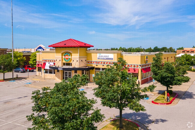
Property Record
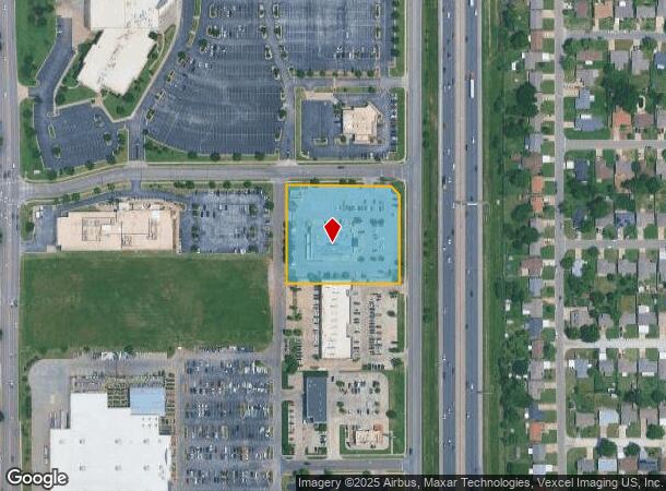
1201 S I 35 Service Rd, Moore, OK 73160


NEARBY LISTINGS FOR SALE OR LEASE
Property Detail
1201 S I 35 Service Rd
Oklahoma City, OK
Riverwalk N Moore
R0144553
RIVERWALK NORTH REPLAT OF BLKS 6 7 AND 8 OF MINUTE CITY SHOPPING CENTER LOT 8 BLOCK 1
Restaurantbuilding
Cleveland
X
Oklahoma
40027C0180J
8
2024
2.16 AC
2024
Moore
201604
Oklahoma City
12,288 SF
DEMOGRAPHICS near 1201 S I 35 Service Rd
1 Mile
3 Mile
5 Mile
2024 Total Population
9,018
78,781
136,414
2029 Population
9,340
81,586
141,375
Pop Growth 2024-2029
+ 3.57%
+ 3.56%
+ 3.64%
Average Age
36
37
38
2024 Total Households
3,569
29,811
52,119
HH Growth 2024-2029
+ 3.73%
+ 3.73%
+ 3.82%
Median Household Inc
$63,314
$71,734
$71,438
Avg Household Size
2.50
2.60
2.50
2024 Avg HH Vehicles
2.00
2.00
2.00
Median Home Value
$140,587
$169,793
$185,240
Median Year Built
1980
1992
1992
Nearby Places
Map Layers
Map Styles
 Street
 Aerial
- Restaurants
- Banks
- Shops
- Fitness
- Groceries
PUBLIC TRANSPORTATION
COMMUTER RAIL
Norman Amtrak Station (Heartland Flyer - Amtrak)
DRIVE
WALK
Distance
Norman Amtrak Station (Heartland Flyer - Amtrak)
15 min
8.6 mi
AIRPORT
Will Rogers World
DRIVE
WALK
Distance
Will Rogers World
25 min
13.4 mi
Freight Ports
Tulsa Port Of Catoosa
DRIVE
WALK
Distance
Tulsa Port Of Catoosa
146 min
132.7 mi
SALE & LEASE HISTORY
LISTING DATE
SALE/LEASE

Apr 05, 2021
For Lease
Nearby Properties
Address
Land Use
TOTAL SIZE
Lot Size
Zoning
Address
Land Use
TOTAL SIZE
Lot Size
Zoning
210,816 SF
10.45 AC
Address
Land Use
TOTAL SIZE
Lot Size
Zoning
1,600 SF
25 AC
Address
Land Use
TOTAL SIZE
Lot Size
Zoning
Address
Land Use
TOTAL SIZE
Lot Size
Zoning
50.08 AC
Address
Land Use
TOTAL SIZE
Lot Size
Zoning
29.38 AC
Address
Land Use
TOTAL SIZE
Lot Size
Zoning
Address
Land Use
TOTAL SIZE
Lot Size
Zoning
0.16 AC
C6
Address
Land Use
TOTAL SIZE
Lot Size
Zoning
40.15 AC
AA
Address
Land Use
TOTAL SIZE
Lot Size
Zoning
155.94 AC
Address
Land Use
TOTAL SIZE
Lot Size
Zoning
11.36 AC
C4
Address
Land Use
TOTAL SIZE
Lot Size
Zoning
Address
Land Use
TOTAL SIZE
Lot Size
Zoning
5.14 AC
Address
Land Use
TOTAL SIZE
Lot Size
Zoning
44,478 SF
2.44 AC
Address
Land Use
TOTAL SIZE
Lot Size
Zoning
31,216 SF
10 AC
Address
Land Use
TOTAL SIZE
Lot Size
Zoning
15.61 AC
C1
Address
Land Use
TOTAL SIZE
Lot Size
Zoning
2,200 SF
12.41 AC
Address
Land Use
TOTAL SIZE
Lot Size
Zoning
Address
Land Use
TOTAL SIZE
Lot Size
Zoning
0.77 AC
Address
Land Use
TOTAL SIZE
Lot Size
Zoning
14,714 SF
14.41 AC
Address
Land Use
TOTAL SIZE
Lot Size
Zoning
0.64 AC
Address
Land Use
TOTAL SIZE
Lot Size
Zoning
10.81 AC
Address
Land Use
TOTAL SIZE
Lot Size
Zoning
1.40 AC
Address
Land Use
TOTAL SIZE
Lot Size
Zoning
104.87 AC
Address
Land Use
TOTAL SIZE
Lot Size
Zoning
33,780 SF
17.24 AC
Address
Land Use
TOTAL SIZE
Lot Size
Zoning
18.41 AC
Address
Land Use
TOTAL SIZE
Lot Size
Zoning
18,672 SF
8.53 AC
Address
Land Use
TOTAL SIZE
Lot Size
Zoning
4,656 SF
14.96 AC
Address
Land Use
TOTAL SIZE
Lot Size
Zoning
3.54 AC
Address
Land Use
TOTAL SIZE
Lot Size
Zoning
29,174 SF
16.62 AC
Address
Land Use
TOTAL SIZE
Lot Size
Zoning
191,355 SF
13.41 AC
The World's #1 Commercial Real Estate Marketplace
Connect with us
© 2025 CoStar Group
The information above has been obtained from sources believed reliable. While we do not doubt its accuracy we have not verified it and make no guarantee, warranty or representation about it. It is your responsibility to independently confirm its accuracy and completeness. Any projections, opinions, assumptions, or estimates used are for example only and do not represent the current or future performance of the property. The value of this transaction to you depends on tax and other factors which should be evaluated by your tax, financial, and legal advisors. You and your advisors should conduct a careful, independent investigation of the property to determine to your satisfaction the suitability of the property for your needs.